

By Jamie Thompson
FireRescue1 Editor
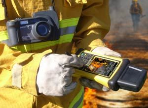 Photo courtesy of SDG Systems The system allows firefighters to photograph the scene and then send it to incident command. |
It’s a challenge most command centers face during wildfire season — receiving timely, accurate images directly from the fire line.
Using a variety of technologies, a new system is aiming to offer near real-time incident intelligence, improving situational awareness both on the fire line and at command during wildfires.
The Fire Location and Incident Reporting (FLAIR) system enables a firefighter on the fire line to categorize, annotate, map, and wirelessly send geocoded and compass-coded digital photographs to a secure server.
This software creates web-based data from the images, which are viewable on the command post’s computer within Google Maps and Google Earth.
“Traditionally the way things have been done is that images would be uploaded at the end of the day, and then the following morning everyone at the operations center would gather together and look over the images,” said Todd Blumer, president of SDG Systems, which is marketing the new product.
“This delay of information can really hamper the firefighting efforts.”
The new system is set to go on the market in July, and is currently undergoing field testing in Santa Barbara City, California.
When it goes on sale, the FLAIR package will include the mobile software, a Ricoh 500SE camera with SE-3 GPS and compass module, a rugged Trimble Nomad handheld computer, and a hard-shell carry case for a retail price of $3,599 per user.
Blumer said while images may be sent to the incident command post using a regular cell phone, the images are usually not categorized, edited or geocoded.
The FLAIR system actually allows the user to categorize the images, highlight and describe important objects on the images using an edit feature, and map the images, he added.
It works by the firefighter taking a photo with the Ricoh 500SE, and then the image is automatically geo-tagged with location and direction by the camera’s GPS and compass module.
Images can then be sent wirelessly to the handheld computer. Before sending to the command post, the user can first use an editing screen where images can be drawn on, cropped, have notes added to it and be assigned an incident command system map symbol to represent its category.
“The near real-time aspect of the system is a key component, but the other really important aspect is the fact you can categorize the images,” Blumer said.
“It means back at the operations center, they will be able to see if a captain, for example, is proposing they need a hand line at a particular location in near real-time.”
For details on field-testing the new system, e-mail Brian Fuller at bfuller@sdgsystems.com.